
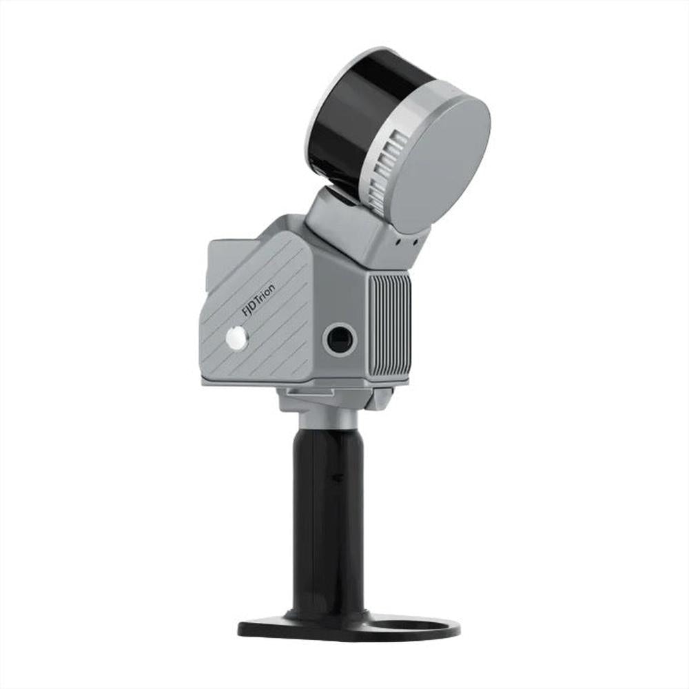
FJD Trion S2 LiDAR Scanner Package
Request a Quote
Key Features
- 3D Scanner Handheld High-precision LiDAR scanner for 3D mapping and modeling applications
- Best 3D Scanners; Captures detailed point cloud data for terrain and structure analysis
- Lightweight and easy to integrate with drones or vehicles
- Real-time data capture with powerful processing capabilities
- Ideal for surveying, agriculture, and infrastructure projects
Request a Quote
Choose options
- Description
- Refund & Return Policy
- Shipping Policy
- FAQ's
FJD Trion S2 LiDAR Scanner Package
Overview
The FJD Trion S2 3D LiDAR Scanner Package is a high-precision, multi-environment 3D mapping system designed for surveying, construction, mining, forestry, and geospatial data capture. With industry-leading accuracy, multi-channel LiDAR technology, and seamless GNSS integration, the S2 delivers rapid, reliable results in aerial and terrestrial applications. This package is compact, lightweight, and weather-resistant, optimized for efficiency in various field environments.
Key Features of LiDAR Scanner Package
-
High-Precision 3D Scanner Technology – Accurate to ±1.2 cm relative and ±3 cm absolute for dependable measurements.
-
Long-Range Scanning – Capable of scanning up to 120 m at 80% reflectivity, ensuring extensive data capture.
-
Fast Data Capture – Delivers 320,000 measurement points per second for efficient mapping.
-
360° × 270° Field of View – Provides full environment coverage for comprehensive data collection.
-
Dual 12 MP Cameras – Offer 200° FOV with Visual SLAM for improved mapping and visualization.
-
GNSS & RTK Support – Multi-constellation positioning ensures superior accuracy in varying settings.
-
Lightweight & Portable Design – Weighs only 1.8 kg, excluding battery and accessories for easy transport.
-
Ample Storage – Includes 512 GB onboard storage, expandable up to 1 TB for large datasets.
-
Flexible Export Formats – Supports .las, .ply, .pts, .e57 formats for seamless GIS and CAD workflows.
Technical Specifications
LiDAR System
-
Range: 120 m at 80% reflectivity, 80 m at 10% reflectivity for varied conditions
-
Channels: 16 to ensure thorough data acquisition
-
Speed: 320,000 points per second for rapid scans
-
Field of View (FOV): 360° horizontally and 270° vertically
-
Safety Level: Class 1, 905 nm eye-safe laser
System Parameters
-
Relative Accuracy: Precise to 1.2 cm for detailed mapping
-
Absolute Accuracy: Up to 3 cm for reliable positioning
-
Weight: Only 1.8 kg (excluding battery and attachments)
-
Battery Life: Approximately 3 hours using 1 set of 2 batteries
-
Storage: 512 GB onboard, expandable to 1 TB for extended operations
-
Operating Temperature Range: Between -20°C and 50°C for diverse environments
-
Power Consumption: 25 W to optimize battery use
-
Dimensions: Compact 107 × 118 × 398 mm including base and battery
-
Data Export Options: Wi-Fi, USB Type-C, USB Type-A for easy data transfer
-
Point Cloud Formats: Supports .las, .ply, .pts, and .e57 file formats
-
Power Supply: 10.8 V, 3 A for reliable operation
Camera
-
Resolution: Dual 12 MP cameras for detailed imaging
-
Field of View: Wide 200° FOV for comprehensive coverage
-
Visual SLAM: Supported to enhance mapping accuracy
-
Image Export: Supported for easy photo sharing
-
Image Format: JPEG (.jpg) for compatibility
GNSS
-
Satellite Constellations Supported:
-
BDS: B1I / B2I / B3I / B1C / B2a / B2b
-
GPS: L1 C/A / L1C / L2P (Y) / L2C / L5
-
GLONASS: G1 / G2 / G3
-
Galileo: E1 / E5a / E5b / E6
-
QZSS: L1C/A / L1C / L2C / L5
-
-
RTK Accuracy: Horizontal 8 mm + 1 ppm RMS, Vertical 15 mm + 1 ppm RMS
-
PPK: Supported for post-processing kinematic corrections
What’s Included in the LiDAR Scanner Package?
-
FJD Trion S2 LiDAR Scanner
-
Mounting Tripod for stable setup
-
Protective Carrying Case to safeguard your equipment
-
Battery Set & Charger for extended use
-
Calibration Kit to maintain measurement accuracy
-
Data Processing Software License included for seamless workflow
Compatibility & Add-Ons
-
Compatible with AutoCAD, GIS, and civil engineering software for versatile use.
-
Additional battery packs are available for longer operational times.
-
Supports mobile app integration for remote monitoring capabilities.
Manuals also available before purchase :)
Delivery Time (U.S. Customers): 1–2 weeks from order confirmation via FJDynamics U.S. warehouse.
Your Tech Haven – Refund & Return Policy for FJDynamics Products
We are proud to offer advanced FJDynamics 3D scanning technology through an authorized partnership.
To provide clarity and confidence in your purchase, we follow standard professional-grade equipment guidelines:
Returns & Exchanges
-
Due to the specialized nature of these products, all sales are final
-
Returns are not accepted unless the item is damaged during shipping or has a verified manufacturer defect
-
Any return must be pre-approved in writing and received in unused, original condition
Warranty Support
-
All FJDynamics 3D scanners sold through us include manufacturer-backed warranty
-
If you experience a technical issue, our team will assist in coordinating support or warranty service with FJDynamics
Need help? Reach out to us anytime:
support@yourtechhaven.com
Shipping Policy — FJ Dynamics Products
We deliver FJ Dynamics products from authorized U.S. warehouses or via direct factory shipping, depending on stock availability.
Order Processing & Fulfillment
-
Orders are typically processed within 1–2 business days after payment confirmation.
-
Orders placed on weekends or holidays will begin processing the next business day.
-
If items ship from factory or an overseas warehouse, expect longer lead times (5–12 business days) as noted by FJ Dynamics.
Shipping Methods & Delivery Times
-
When shipping from U.S. warehouses, standard delivery is 3–7 business days via FedEx or similar carriers.
-
Heavier orders (exceeding ~67 kg) may be split into multiple shipments to optimize freight handling.
-
In cases of freight or bulky items, you may be contacted to select additional delivery options (liftgate, curbside, etc.).
Free Shipping & Thresholds
-
Some FJ products are eligible for free U.S. shipping (lower 48 states) when the item listing qualifies.
-
Free shipping typically applies to standard delivery to your curb — extra services (inside delivery, white glove) may incur additional charges.
Inspection & Claims
-
Please inspect the package at delivery. If you see visible damage, refuse the delivery or note “Subject to Inspection” on the receipt.
-
Submit clear photos of any damage along with your order number to us within 48 hours.
-
For concealed damage (not apparent until unpacking), notify us immediately with photos.
-
We’ll coordinate with carriers and FJ Dynamics for claims and resolution.
International & Remote Shipping
-
We currently do not offer standard international shipping for FJ Dynamics products.
-
If international orders are possible, they will require a special quote and may incur additional duties, taxes, or customs delays.
Need Help?
-
Email: support@yourtechhaven.com
1. What is included in the FJD Trion S2 LiDAR Scanner Package?
Each package includes:
-
FJD Trion S2 LiDAR Scanner (model based on your selection)
-
Carrying case
-
Data cables and mounting accessories
-
Calibration and setup tools
-
User & quick-start guides
Some packages include extra sensors, upgraded components or software licenses — refer to the product variation for exact details.
2. What is the main difference between the S2, S2 Max, and S2 Pro?
All systems use LiDAR laser scanning to capture accurate 3D spatial data.
The difference is mainly in sensor count, scanning range, and data precision:
|
Model |
Sensors |
Range & Accuracy |
Best For |
|---|---|---|---|
|
S2 |
Standard sensor set |
General 3D scanning / surveying |
Everyday mapping & inspection |
|
S2 Max |
32 sensors |
Enhanced precision & environmental capture |
Engineering-grade mapping & construction |
|
S2 Pro |
32 sensors + advanced stabilization |
Highest accuracy in complex terrain |
High-stakes surveying & architectural modeling |
3. Does the scanner require special training to use?
No advanced training is required. The system is designed for straightforward field use, and includes:
-
Step-by-step on-screen guidance
-
Automatic calibration
-
Easy workflow upload to FJD mapping software
We also provide optional onboarding support and setup assistance if needed.
4. Which industries typically use the FJD Trion S2 LiDAR Scanner?
Common applications include:
-
Land surveying & site measurement
-
Construction & architectural planning
-
Forestry & environmental analysis
-
Asset inspection and infrastructure documentation
-
BIM (Building Information Modeling)
-
3D reconstruction for digital twin creation
5. What devices is the scanner compatible with?
You can export and process data on:
-
Windows & Mac computers
-
FJD mobile app (iOS & Android support available)
-
FJD professional mapping software
-
Standard GIS & CAD workflows (including .las, .ply, .obj formats)
6. How accurate is the data captured?
Depending on the model:
-
Accuracy ranges ~1–3 cm
-
Scanning range varies by model and sensor count
This makes the S2 lineup suitable for professional-grade surveying and engineering applications.
7. Can I use the scanner outdoors in harsh conditions?
Yes. The scanner is built with a rugged, weather-resistant housing for:
-
Fieldwork
-
Construction sites
-
Forestry environments
Designed to handle heat, dust, and outdoor transport.
8. Do you offer warranty and support?
Yes — all scanners come with:
-
Manufacturer warranty (duration varies by supplier agreement)
-
Access to online documentation, firmware updates, and support channels
Extended coverage or training services may be available upon request.
9. How long does shipping take?
Standard lead times usually between are 1 - 3 weeks. We will provide:
-
Tracking confirmation
-
Delivery schedule updates
10. Do I need additional software to process scans?
The scanner includes base viewing and exporting tools.
Advanced mapping, 3D modeling, and analysis may require:
-
FJD mapping suite
-
Third-party CAD, BIM, or GIS software (AutoCAD, ArcGIS, etc.)